About MARSH
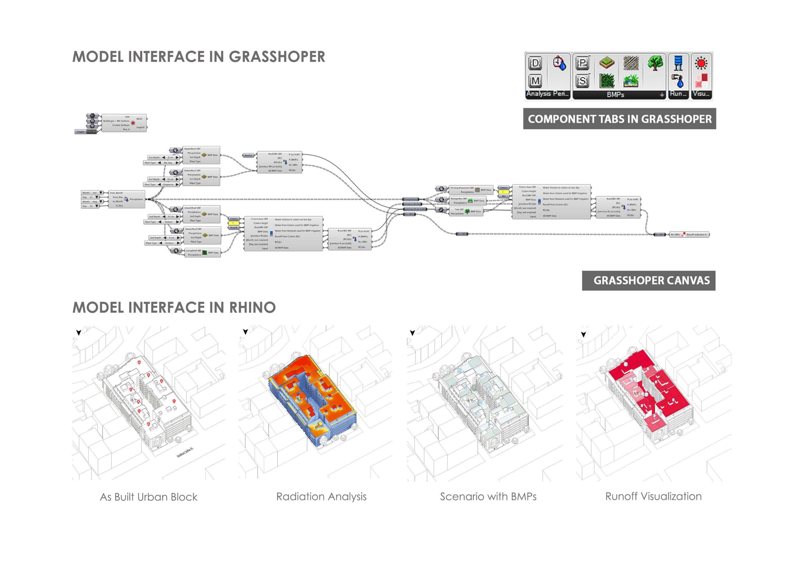
MARSH (Model for Assessing Runoff and Stormwater Harvesting) is a user-friendly 3D computational tool designed to help architects and urban planners effectively manage stormwater in cities. Integrated with Rhino and Grasshopper software, MARSH allows users to simulate, analyze, and visualize stormwater runoff and rainwater harvesting strategies directly on urban design models.
How MARSH works
MARSH’s structure is organized into four main categories, providing a comprehensive yet accessible approach to stormwater management:
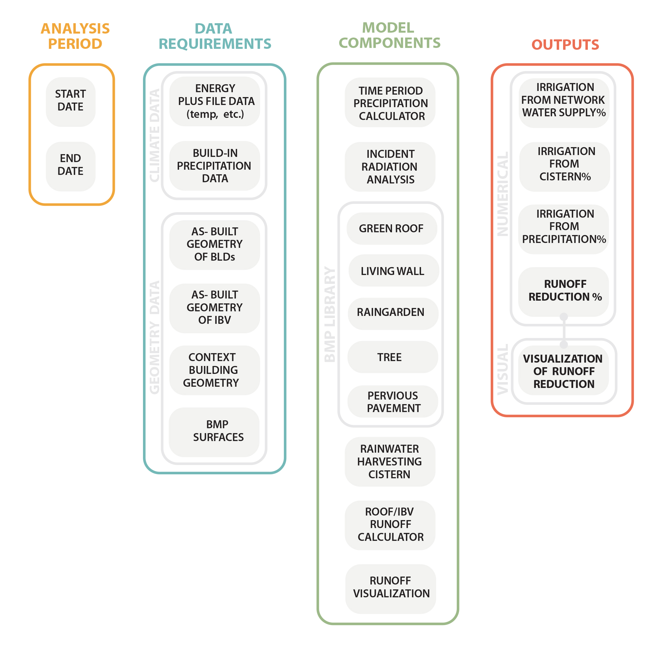
1. Analysis Period
Users define the start and end dates of the simulation, setting the time frame for evaluating stormwater strategies — from a single day up to a full year. This flexible timescale helps assess both short-term events (like heavy storms) and long-term water use patterns.
2. Data Requirements
MARSH uses two key types of data:
- Climate Data:
Historical weather data from EnergyPlus files and built-in precipitation records for Athens form the foundation for accurate climate simulations and runoff calculations. - Geometry Data:
Precise geometric information ensures realistic modeling of the urban environment, including:- As-Built Geometry of Buildings — details of existing buildings and their runoff contribution.
- As-Built Geometry of Inner Block Void — internal open spaces that affect local runoff.
- Context Building Geometry — surrounding structures that influence urban drainage behavior.
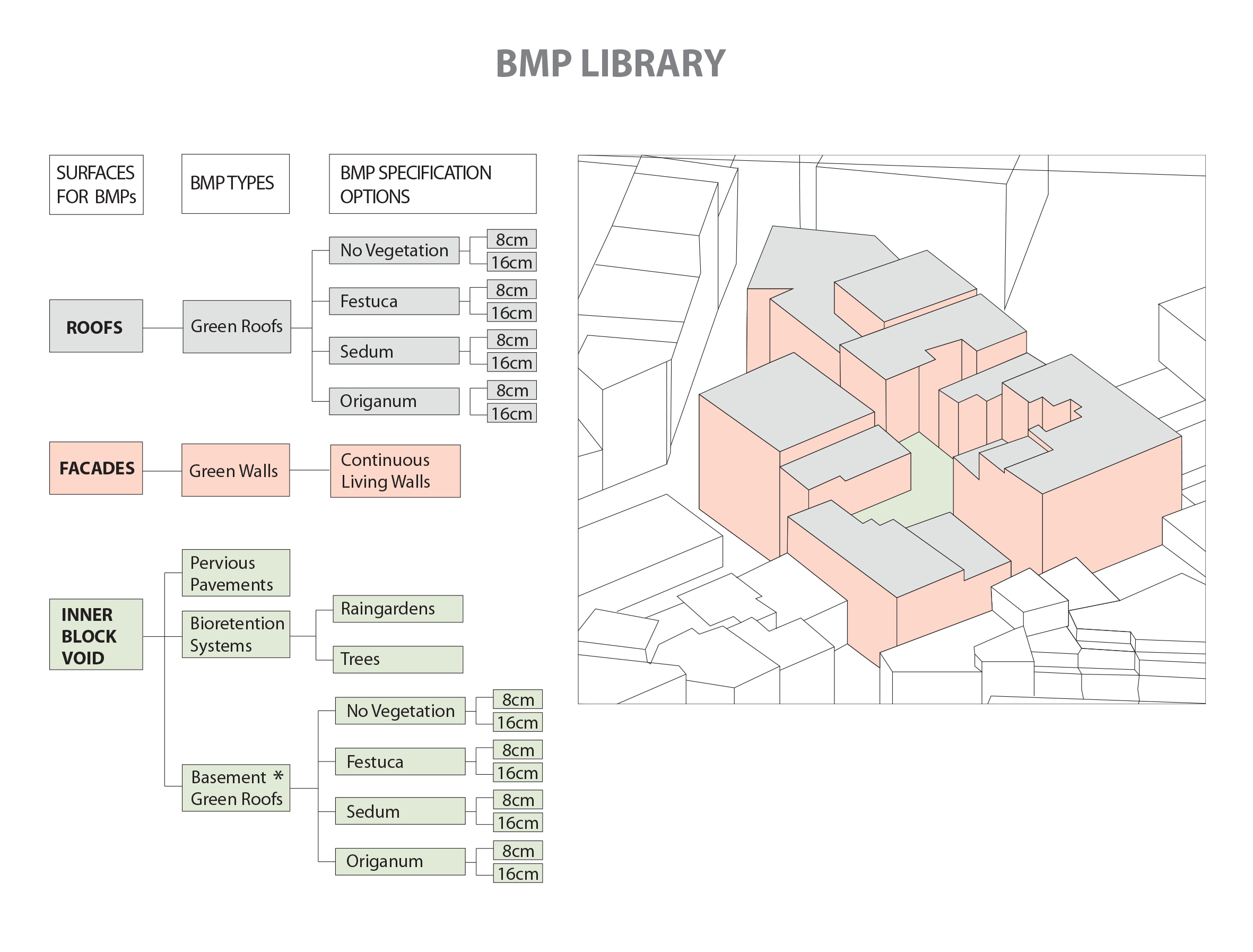
BMP Surfaces — exact areas of selected Best Management Practices (BMPs), such as green roofs or permeable pavements.
3. Model Components
MARSH combines several interconnected components to simulate urban stormwater dynamics:
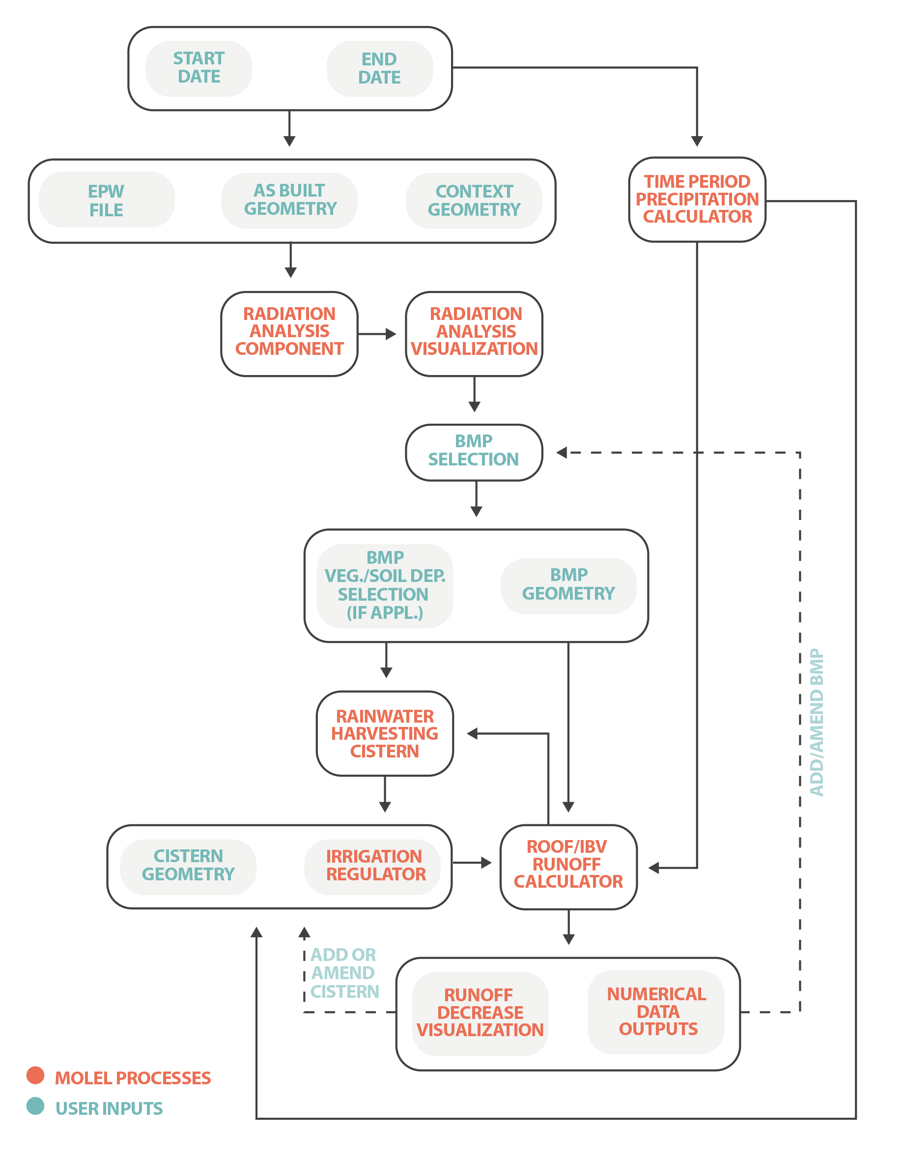
- Time Period Precipitation Calculator:
Calculates rainfall data over the chosen timeframe to evaluate BMP effectiveness. - Incident Radiation Analysis:
Assesses solar radiation exposure, essential for understanding how BMPs like green roofs or living walls perform. - BMP Library:
Includes individual models for various BMPs—green roofs, living walls, rain gardens, trees, and pervious pavements—to simulate their hydrological behavior. - Rainwater Harvesting Cistern:
Models the collection and storage of rainwater, reducing dependency on city water for irrigation. - Roof/Inner Block Void Runoff Calculation:
Quantifies runoff from impervious rooftops and internal open spaces, accounting for BMP coverage.
Runoff Visualization:
Generates an interactive 3D, color-coded representation of runoff reduction directly in Rhino, helping users identify where BMPs have the greatest impact.
4. Outputs
MARSH provides both numerical and visual results to guide sustainable design:
- Numerical Outputs:
- Irrigation from Network Water Supply (%): Amount of irrigation water sourced from municipal supply.
- Irrigation from Cistern(s) (%): Percentage of irrigation water supplied by harvested rainwater.
- Irrigation from Precipitation (%): Portion of irrigation water supplied directly by rainfall.
- Runoff Reduction (%): Overall decrease in stormwater runoff due to BMP implementation.
Visual Outputs:
The 3D runoff reduction visualization uses a color scale (from red to white) to highlight areas with higher and lower runoff reductions, making it easy to understand and communicate the effectiveness of stormwater strategies.
Spatial Scale, Time Scale & Analysis Period
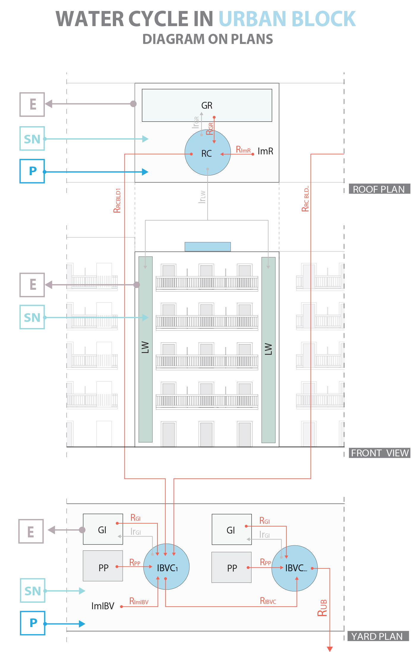
Model Spatial Scale
MARSH focuses on stormwater management within an urban block in Athens, including rooftops, building facades, and inner block voids. This targeted scale enables practical retrofit solutions on:
- Flat rooftop surfaces
- Facades
- Inner block void surfaces
The model can also be expanded to city-scale for broader stormwater management, though this increases computational needs.
Model Time Scale
Simulations use a daily time step balancing accuracy and efficiency, reflecting daily rainfall changes and aiding urban planning decisions.
Analysis Period
Users can select an analysis period from one day up to one year:
- One day for event-specific runoff assessment
- Multiple days for seasonal performance analysis
- One year for long-term planning aligned with development cycles
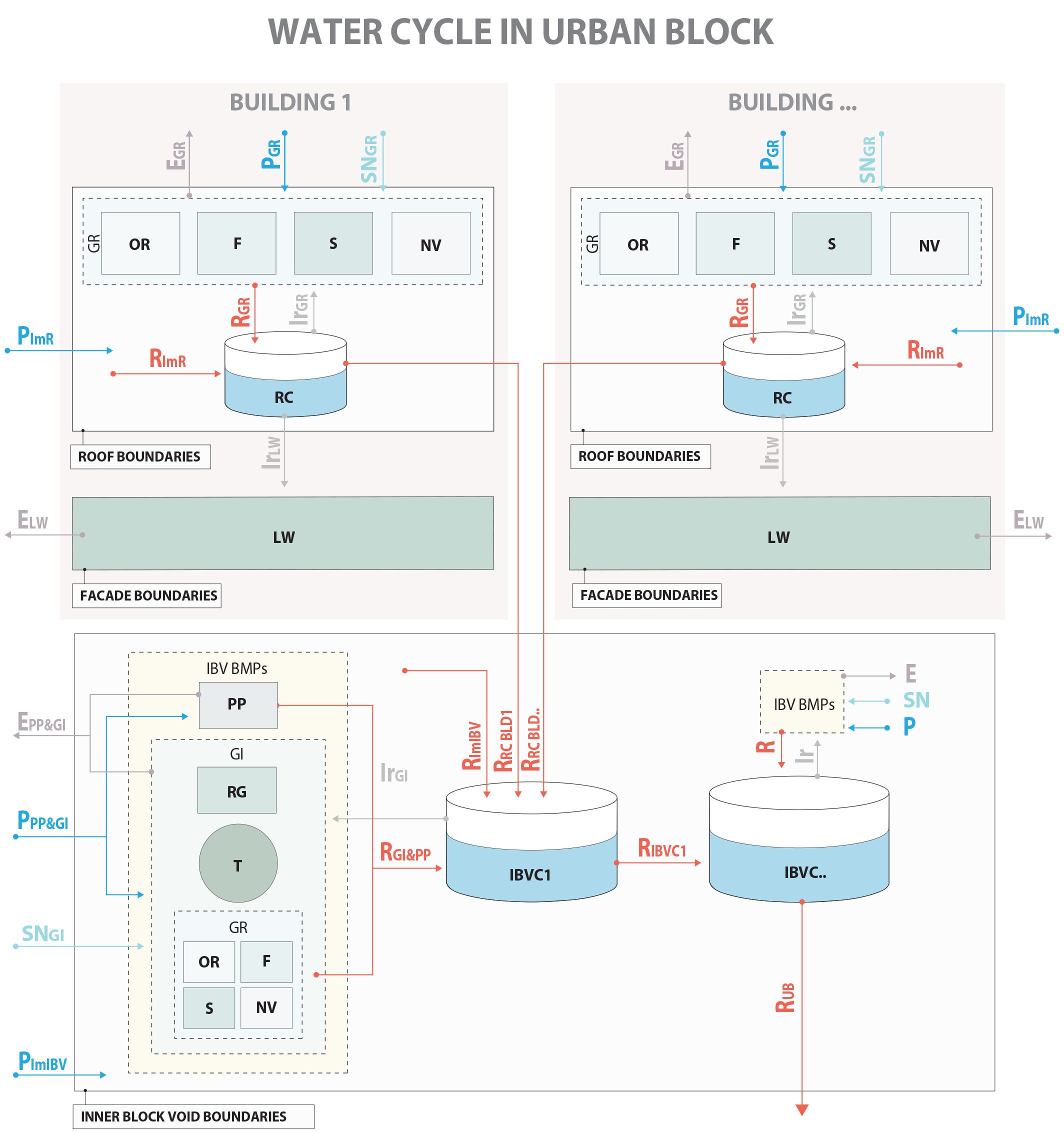
Water Cycle in the Model
- Simulates urban water flow: rainfall, irrigation, evaporation, and runoff
- Captures rainwater via green roofs, green walls, and cisterns
- Harvested rainwater is stored and reused for irrigation
- Backup irrigation from supply network when rainwater is insufficient
- Cisterns arranged to collect runoff efficiently and reduce water waste
- Supports a sustainable, closed-loop urban water cycle
Why MARSH Matters
As urban areas grow and climate challenges intensify, managing stormwater sustainably is crucial. MARSH empowers architects — even those without extensive hydrology training — to design smarter, greener urban spaces by integrating water-sensitive principles seamlessly into their workflow.
With MARSH, users can explore different scenarios, visualize their impacts, and make data-driven decisions that contribute to resilient, livable, and sustainable cities.